Search for Grid Square by Postcode
TQ17
Based in the London English Region & South East English Region.
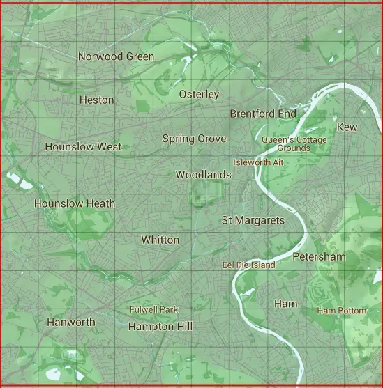
The TQ17 10 square kilometre grid intersects with the settlements of Acton,Brentford,Chiswick,Coombe,Cranford,Ealing,East Sheen,Feltham,Gunersbury,Ham,Hampton,Hanwell,Hanworth,Hayes Hillingdon,Heathrow Airport,Heston,Hounslow,Isleworth,Kew,Kingston upon Thames,Mortlake,Norbiton,North Sheen,Osterley,Petersham,Richmond upon Thames,Southall,Sunbury-on-Thames,Teddington & Twickenham.
TQ17
TQ17 is within the post towns of Brentford, Middlesex, Feltham, Middlesex, Hampton, Middlesex, Hayes, Middlesex, Hounslow, Middlesex, Isleworth, Middlesex, Kingston Upon Thames, Surrey, London, Middlesex, London, Surrey, Richmond, Surrey, Southall, Middlesex, Sunbury-on-thames, Middlesex, Teddington, Middlesex & Twickenham, Middlesex.
The square is within Ealing London Boro, Hillingdon London Boro, Hounslow London Boro, Kingston upon Thames London Boro, Richmond upon Thames London Boro & Spelthorne District councils.
The TQ17 national grid square measures 10 km by 10 km and has an area of 1,000 kilometres squared.
The technical term for a 10 km map square is a Hectad.
When this 10 km square is divided into a grid 10 by 10 it gives the next size of grid square. This unit is called a Monad and measures 1km square. 100 monads fit in a 10km square.
Out of the monads generated from square TQ17, 516 are land and -416 are sea. Sea squares are disregarded on this site as they contain no land features.
|
|
|
|
|
|
 |
|
|
|
|
|
 |  |  |  |  |  |  |  |  |  |
 |  |  |  |  |  |  |  |  |  |
 |  |  |  |  |  |  |  |  |  |
 |  |  |  |  |  |  |  |  |  |
 |  |  |  |  |  |  |  |  |  |
 |  |  |  |  |  |  |  |  |  |
 |  |  |  |  |  |  |  |  |  |
 |  |  |  |  |  |  |  |  |  |
 |  |  |  |  |  |  |  |  |  |
 |  |  |  |  |  |  |  |  |  |
| Corner | Latitude | Longitude | Easting | Northing |
|---|---|---|---|---|
| South West Corner | 51.416326 | -0.419472 | 510000 | 170000 |
| South East Corner | 51.416326 | -0.272338 | 520000 | 170000 |
| North West Corner | 51.508234 | -0.419472 | 510000 | 180000 |
| North East Corner | 51.508234 | -0.272338 | 520000 | 180000 |