Search for Grid Square by Postcode
NH79
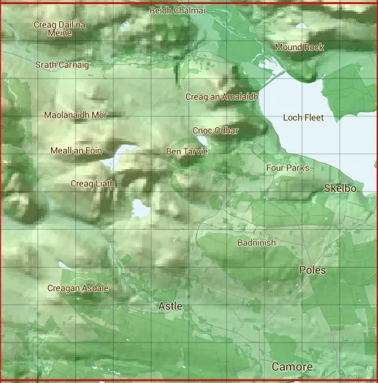
Based in the Highlands and Islands region of Scotland.
The NH79 10 square kilometre grid intersects with the settlements of Camore,Dornoch,Embo Street,Evelix & Skelbo Muir.
NH79
NH79 is within the post towns of Dornoch, Sutherland, Golspie, Sutherland & Rogart, Sutherland.
The square is within Highland council.
The NH79 national grid square measures 10 km by 10 km and has an area of 1,000 kilometres squared.
The technical term for a 10 km map square is a Hectad.
When this 10 km square is divided into a grid 10 by 10 it gives the next size of grid square. This unit is called a Monad and measures 1km square. 100 monads fit in a 10km square.
Out of the monads generated from square NH79, 456 are land and -356 are sea. Sea squares are disregarded on this site as they contain no land features.
|
|
|
|
|
|
 |
|
|
|
|
|
 |  |  |  |  |  |  |  |  |  |
 |  |  |  |  |  |  |  |  |  |
 |  |  |  |  |  |  |  |  |  |
 |  |  |  |  |  |  |  |  |  |
 |  |  |  |  |  |  |  |  |  |
 |  |  |  |  |  |  |  |  |  |
 |  |  |  |  |  |  |  |  |  |
 |  |  |  |  |  |  |  |  |  |
 |  |  |  |  |  |  |  |  |  |
 |  |  |  |  |  |  |  |  |  |
| Corner | Latitude | Longitude | Easting | Northing |
|---|---|---|---|---|
| South West Corner | 57.880447 | -4.199347 | 270000 | 890000 |
| South East Corner | 57.880447 | -4.025359 | 280000 | 890000 |
| North West Corner | 57.973011 | -4.199347 | 270000 | 900000 |
| North East Corner | 57.973011 | -4.025359 | 280000 | 900000 |