Search for Grid Square by Postcode
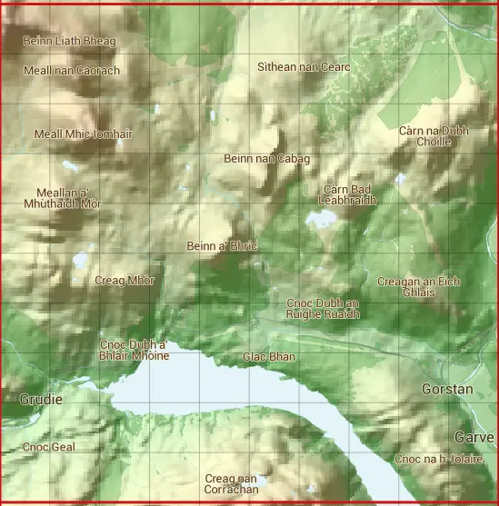
NH36
Based in the Highlands and Islands region of Scotland.
The NH36 10 square kilometre grid intersects with the settlements of Garve & Lochluichart.
NH36
NH36 is within the post towns of Garve, Ross-shire & Strathpeffer, Ross-shire.
The square is within Highland council.
The NH36 national grid square measures 10 km by 10 km and has an area of 1,000 kilometres squared.
The technical term for a 10 km map square is a Hectad.
When this 10 km square is divided into a grid 10 by 10 it gives the next size of grid square. This unit is called a Monad and measures 1km square. 100 monads fit in a 10km square.
Out of the monads generated from square NH36, 485 are land and -385 are sea. Sea squares are disregarded on this site as they contain no land features.
|
|
|
|
|
|
 |
|
|
|
|
|
 |  |  |  |  |  |  |  |  |  |
 |  |  |  |  |  |  |  |  |  |
 |  |  |  |  |  |  |  |  |  |
 |  |  |  |  |  |  |  |  |  |
 |  |  |  |  |  |  |  |  |  |
 |  |  |  |  |  |  |  |  |  |
 |  |  |  |  |  |  |  |  |  |
 |  |  |  |  |  |  |  |  |  |
 |  |  |  |  |  |  |  |  |  |
 |  |  |  |  |  |  |  |  |  |
| Corner | Latitude | Longitude | Easting | Northing |
|---|---|---|---|---|
| South West Corner | 57.597879 | -4.853324 | 230000 | 860000 |
| South East Corner | 57.597879 | -4.679173 | 240000 | 860000 |
| North West Corner | 57.691260 | -4.853324 | 230000 | 870000 |
| North East Corner | 57.691260 | -4.679173 | 240000 | 870000 |
1 KM Squares within the NH36 10 KM Square
NH3060 NH3061 NH3062 NH3063 NH3064 NH3065 NH3066 NH3067 NH3068 NH3069 NH3160 NH3161 NH3162 NH3163 NH3164 NH3165 NH3166 NH3167 NH3168 NH3169 NH3260 NH3261 NH3262 NH3263 NH3264 NH3265 NH3266 NH3267 NH3268 NH3269 NH3360 NH3361 NH3362
NH3363 NH3364 NH3365 NH3366 NH3367 NH3368 NH3369 NH3460 NH3461 NH3462 NH3463 NH3464 NH3465 NH3466 NH3467 NH3468 NH3469 NH3560 NH3561 NH3562 NH3563 NH3564 NH3565 NH3566 NH3567 NH3568 NH3569 NH3660 NH3661 NH3662 NH3663 NH3664 NH3665