Search for Grid Square by Postcode
TR16
Based in the South East English Region.
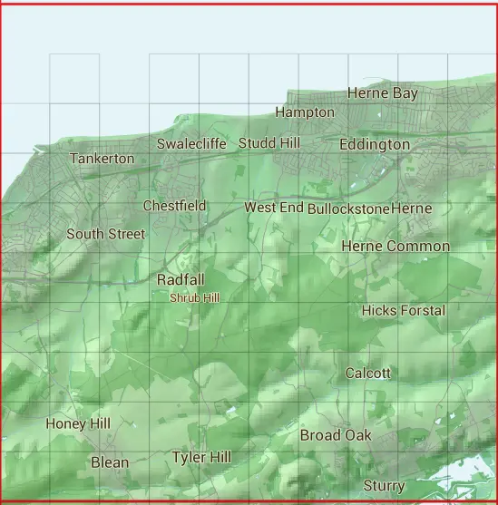
The TR16 10 square kilometre grid intersects with the settlements of Blean,Broad Oak,Broomfield,Calcott,Canterbury,Denstroude,Eddington,Fordwich,Greenhill,Herne,Herne Bay,Herne Common,Hersden,Honey Hill,Hunters Forstal,Knave's Ash,Radfall,Sturry,Tyler Hill,West End,Westbere & Whitstable.
TR16
TR16 is within the post towns of Canterbury, Kent, Herne Bay, Kent & Whitstable, Kent.
The square is within Canterbury District & Swale District councils.
The TR16 national grid square measures 10 km by 10 km and has an area of 1,000 kilometres squared.
The technical term for a 10 km map square is a Hectad.
When this 10 km square is divided into a grid 10 by 10 it gives the next size of grid square. This unit is called a Monad and measures 1km square. 100 monads fit in a 10km square.
Out of the monads generated from square TR16, 190 are land and -90 are sea. Sea squares are disregarded on this site as they contain no land features.
|
|
|
|
|
|
 |
|
|
|
|
|
 |  |  |  |  |  |  |  | ||
 |  |  |  |  |  |  |  |  |  |
 |  |  |  |  |  |  |  |  |  |
 |  |  |  |  |  |  |  |  |  |
 |  |  |  |  |  |  |  |  |  |
 |  |  |  |  |  |  |  |  |  |
 |  |  |  |  |  |  |  |  |  |
 |  |  |  |  |  |  |  |  |  |
 |  |  |  |  |  |  |  |  |  |
| Corner | Latitude | Longitude | Easting | Northing |
|---|---|---|---|---|
| South West Corner | 51.296605 | 1.011098 | 610000 | 160000 |
| South East Corner | 51.296605 | 1.160493 | 620000 | 160000 |
| North West Corner | 51.390171 | 1.011098 | 610000 | 170000 |
| North East Corner | 51.390171 | 1.160493 | 620000 | 170000 |