Search for Grid Square by Postcode
TQ36
Based in the London English Region & South East English Region.
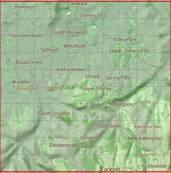
The TQ36 10 square kilometre grid intersects with the settlements of Addington,Anerley,Beckenham,Beddington,Broad Green,Bromley,Coulsdon,Croydon,Elmers End,Farleigh,Fickleshole,Forestdale,Hayes Bromley,Kenley,Mitcham,Monks Orchard,New Addington,Norbury,Penge,Purley,Roundshaw,Sanderstead,Selhurst,Selsdon,Shirley,South Norwood,Spring Park,Streatham,Streatham Vale,Thornton Heath,Upper Norwood,Waddon,Wallington,West Wickham & Woodside.
TQ36
TQ36 is within the post towns of Beckenham, Kent, Bromley, Kent, Coulsdon, Surrey, Croydon, Surrey, Kenley, Surrey, Keston, Kent, London, Surrey, Mitcham, Surrey, Purley, Surrey, South Croydon, Surrey, Thornton Heath, Surrey, Wallington, Surrey, Warlingham, Surrey, West Wickham, Kent & Westerham, Kent.
The square is within Bromley London Boro, Croydon London Boro, Lambeth London Boro, Merton London Boro, Sutton London Boro & Tandridge District councils.
The TQ36 national grid square measures 10 km by 10 km and has an area of 1,000 kilometres squared.
The technical term for a 10 km map square is a Hectad.
When this 10 km square is divided into a grid 10 by 10 it gives the next size of grid square. This unit is called a Monad and measures 1km square. 100 monads fit in a 10km square.
Out of the monads generated from square TQ36, 520 are land and -420 are sea. Sea squares are disregarded on this site as they contain no land features.
|
|
|
|
|
|
 |
|
|
|
|
|
 |  |  |  |  |  |  |  |  |  |
 |  |  |  |  |  |  |  |  |  |
 |  |  |  |  |  |  |  |  |  |
 |  |  |  |  |  |  |  |  |  |
 |  |  |  |  |  |  |  |  |  |
 |  |  |  |  |  |  |  |  |  |
 |  |  |  |  |  |  |  |  |  |
 |  |  |  |  |  |  |  |  |  |
 |  |  |  |  |  |  |  |  |  |
 |  |  |  |  |  |  |  |  |  |
| Corner | Latitude | Longitude | Easting | Northing |
|---|---|---|---|---|
| South West Corner | 51.321884 | -0.135655 | 530000 | 160000 |
| South East Corner | 51.321884 | 0.011705 | 540000 | 160000 |
| North West Corner | 51.414123 | -0.135655 | 530000 | 170000 |
| North East Corner | 51.414123 | 0.011705 | 540000 | 170000 |