Search for Grid Square by Postcode
TL75
Based in the Eastern English Region.
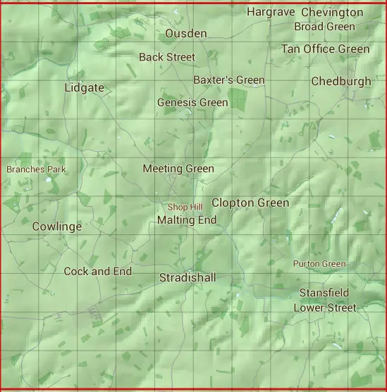
The TL75 10 square kilometre grid intersects with the settlements of Broad Green,Chedburgh,Chevington,Clopton Green,Cowlinge,Denston,Depden,Hargrave,Hawkedon,Lidgate,Lower Street,Ousden,Stradishall,Tan Office Green,Upper Street & Wickhambrook.
TL75
TL75 is within the post towns of Bury St. Edmunds, Suffolk, Haverhill, Suffolk, Newmarket, Suffolk & Sudbury, Suffolk.
The square is within Babergh District, East Cambridgeshire District & West Suffolk District councils.
The TL75 national grid square measures 10 km by 10 km and has an area of 1,000 kilometres squared.
The technical term for a 10 km map square is a Hectad.
When this 10 km square is divided into a grid 10 by 10 it gives the next size of grid square. This unit is called a Monad and measures 1km square. 100 monads fit in a 10km square.
Out of the monads generated from square TL75, 523 are land and -423 are sea. Sea squares are disregarded on this site as they contain no land features.
|
|
|
|
|
|
 |
|
|
|
|
|
 |  |  |  |  |  |  |  |  |  |
 |  |  |  |  |  |  |  |  |  |
 |  |  |  |  |  |  |  |  |  |
 |  |  |  |  |  |  |  |  |  |
 |  |  |  |  |  |  |  |  |  |
 |  |  |  |  |  |  |  |  |  |
 |  |  |  |  |  |  |  |  |  |
 |  |  |  |  |  |  |  |  |  |
 |  |  |  |  |  |  |  |  |  |
 |  |  |  |  |  |  |  |  |  |
| Corner | Latitude | Longitude | Easting | Northing |
|---|---|---|---|---|
| South West Corner | 52.119024 | 0.481807 | 570000 | 250000 |
| South East Corner | 52.119024 | 0.633013 | 580000 | 250000 |
| North West Corner | 52.212007 | 0.481807 | 570000 | 260000 |
| North East Corner | 52.212007 | 0.633013 | 580000 | 260000 |