Search for Grid Square by Postcode
TG12
Based in the Eastern English Region.
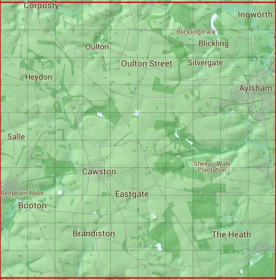
The TG12 10 square kilometre grid intersects with the settlements of Aylsham,Blickling,Booton,Brandiston,Cawston,Corpusty,Eastgate,Hevingham,Heydon,Ingworth,Little London,Little Witchingham,Marsham,Oulton,Oulton Street,Reepham,Salle,The Grove,The Heath & Whitwell Street.
TG12
TG12 is within the post town of Norwich, Norfolk.
The square is within Broadland District & North Norfolk District councils.
The TG12 national grid square measures 10 km by 10 km and has an area of 1,000 kilometres squared.
The technical term for a 10 km map square is a Hectad.
When this 10 km square is divided into a grid 10 by 10 it gives the next size of grid square. This unit is called a Monad and measures 1km square. 100 monads fit in a 10km square.
Out of the monads generated from square TG12, 269 are land and -169 are sea. Sea squares are disregarded on this site as they contain no land features.
|
|
|
|
|
|
 |
|
|
|
|
|
 |  |  |  |  |  |  |  |  |  |
 |  |  |  |  |  |  |  |  |  |
 |  |  |  |  |  |  |  |  |  |
 |  |  |  |  |  |  |  |  |  |
 |  |  |  |  |  |  |  |  |  |
 |  |  |  |  |  |  |  |  |  |
 |  |  |  |  |  |  |  |  |  |
 |  |  |  |  |  |  |  |  |  |
 |  |  |  |  |  |  |  |  |  |
 |  |  |  |  |  |  |  |  |  |
| Corner | Latitude | Longitude | Easting | Northing |
|---|---|---|---|---|
| South West Corner | 52.732883 | 1.109192 | 610000 | 320000 |
| South East Corner | 52.732883 | 1.263773 | 620000 | 320000 |
| North West Corner | 52.826617 | 1.109192 | 610000 | 330000 |
| North East Corner | 52.826617 | 1.263773 | 620000 | 330000 |