Search for Grid Square by Postcode
TF19
Based in the East Midlands English Region.
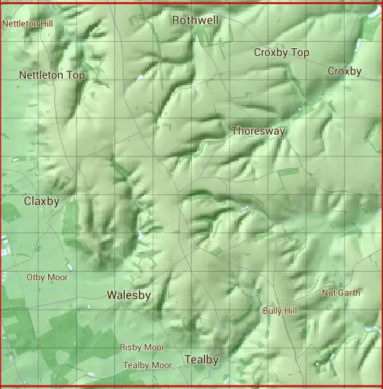
The TF19 10 square kilometre grid intersects with the settlements of Brookenby,Claxby,Market Rasen,Nettleton,Normanby le Wold,Rothwell,Tealby,Tealby Thorpe & Walesby.
TF19
TF19 is within the post towns of Grimsby, Lincolnshire & Market Rasen, Lincolnshire.
The square is within East Lindsey District & West Lindsey District councils.
The TF19 national grid square measures 10 km by 10 km and has an area of 1,000 kilometres squared.
The technical term for a 10 km map square is a Hectad.
When this 10 km square is divided into a grid 10 by 10 it gives the next size of grid square. This unit is called a Monad and measures 1km square. 100 monads fit in a 10km square.
Out of the monads generated from square TF19, 404 are land and -304 are sea. Sea squares are disregarded on this site as they contain no land features.
|
|
|
|
|
|
 |
|
|
|
|
|
 |  |  |  |  |  |  |  |  |  |
 |  |  |  |  |  |  |  |  |  |
 |  |  |  |  |  |  |  |  |  |
 |  |  |  |  |  |  |  |  |  |
 |  |  |  |  |  |  |  |  |  |
 |  |  |  |  |  |  |  |  |  |
 |  |  |  |  |  |  |  |  |  |
 |  |  |  |  |  |  |  |  |  |
 |  |  |  |  |  |  |  |  |  |
 |  |  |  |  |  |  |  |  |  |
| Corner | Latitude | Longitude | Easting | Northing |
|---|---|---|---|---|
| South West Corner | 53.393230 | -0.347207 | 510000 | 390000 |
| South East Corner | 53.393230 | -0.193092 | 520000 | 390000 |
| North West Corner | 53.485251 | -0.347207 | 510000 | 400000 |
| North East Corner | 53.485251 | -0.193092 | 520000 | 400000 |