Search for Grid Square by Postcode
SX39
Based in the South West English Region.
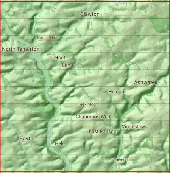
The SX39 10 square kilometre grid intersects with the settlements of Ashwater,Boyton,Clawton,Lana,North Tamerton & St Giles on the Heath.
SX39
SX39 is within the post towns of Beaworthy, Devon, Holsworthy, Devon, Launceston, Cornwall & Lifton, Devon.
The square is within Cornwall & Torridge District councils.
The SX39 national grid square measures 10 km by 10 km and has an area of 1,000 kilometres squared.
The technical term for a 10 km map square is a Hectad.
When this 10 km square is divided into a grid 10 by 10 it gives the next size of grid square. This unit is called a Monad and measures 1km square. 100 monads fit in a 10km square.
Out of the monads generated from square SX39, 348 are land and -248 are sea. Sea squares are disregarded on this site as they contain no land features.
|
|
|
|
|
|
 |
|
|
|
|
|
 |  |  |  |  |  |  |  |  |  |
 |  |  |  |  |  |  |  |  |  |
 |  |  |  |  |  |  |  |  |  |
 |  |  |  |  |  |  |  |  |  |
 |  |  |  |  |  |  |  |  |  |
 |  |  |  |  |  |  |  |  |  |
 |  |  |  |  |  |  |  |  |  |
 |  |  |  |  |  |  |  |  |  |
 |  |  |  |  |  |  |  |  |  |
 |  |  |  |  |  |  |  |  |  |
| Corner | Latitude | Longitude | Easting | Northing |
|---|---|---|---|---|
| South West Corner | 50.684748 | -4.412508 | 230000 | 90000 |
| South East Corner | 50.684748 | -4.266455 | 240000 | 90000 |
| North West Corner | 50.777442 | -4.412508 | 230000 | 100000 |
| North East Corner | 50.777442 | -4.266455 | 240000 | 100000 |