Search for Grid Square by Postcode
ST41
Based in the South West English Region.
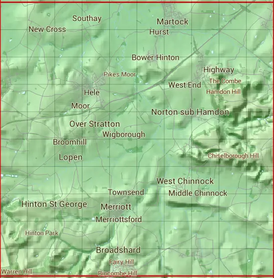
The ST41 10 square kilometre grid intersects with the settlements of Broadshard,Broomhill,Burrow,Chiselborough,Compton Durville,Crewkerne,Dinnington,East Chinnock,East Lambrook,Haselbury Plucknett,Hinton St George,Lopen,Martock,Merriott,Montacute,North Perrott,Norton sub Hamdon,Over Stratton,Puddle Town,Seavington St Mary,Seavington St Michael,Shepton Beauchamp,South Petherton,Stembridge,Stoke sub Hamdon,Tintinhull,Watergore,West Chinnock & West Lambrook.
ST41
ST41 is within the post towns of Crewkerne, Somerset, Hinton St. George, Somerset, Ilminster, Somerset, Martock, Somerset, Merriott, Somerset, Montacute, Somerset, South Petherton, Somerset, Stoke-sub-hamdon, Somerset & Yeovil, Somerset.
The square is within South Somerset District council.
The ST41 national grid square measures 10 km by 10 km and has an area of 1,000 kilometres squared.
The technical term for a 10 km map square is a Hectad.
When this 10 km square is divided into a grid 10 by 10 it gives the next size of grid square. This unit is called a Monad and measures 1km square. 100 monads fit in a 10km square.
Out of the monads generated from square ST41, 506 are land and -406 are sea. Sea squares are disregarded on this site as they contain no land features.
|
|
|
|
|
|
 |
|
|
|
|
|
 |  |  |  |  |  |  |  |  |  |
 |  |  |  |  |  |  |  |  |  |
 |  |  |  |  |  |  |  |  |  |
 |  |  |  |  |  |  |  |  |  |
 |  |  |  |  |  |  |  |  |  |
 |  |  |  |  |  |  |  |  |  |
 |  |  |  |  |  |  |  |  |  |
 |  |  |  |  |  |  |  |  |  |
 |  |  |  |  |  |  |  |  |  |
 |  |  |  |  |  |  |  |  |  |
| Corner | Latitude | Longitude | Easting | Northing |
|---|---|---|---|---|
| South West Corner | 50.886349 | -2.855995 | 340000 | 110000 |
| South East Corner | 50.886349 | -2.712194 | 350000 | 110000 |
| North West Corner | 50.977220 | -2.855995 | 340000 | 120000 |
| North East Corner | 50.977220 | -2.712194 | 350000 | 120000 |