Search for Grid Square by Postcode
ST19
Based in the South Wales Central region of Scotland & South Wales East region of Scotland.
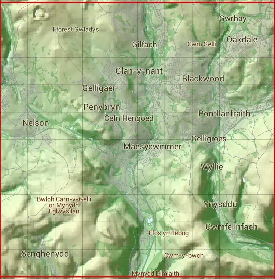
The ST19 10 square kilometre grid intersects with the settlements of Aberbargod,Abertridwr,Argoed,Bargod,Bedwellty / Bedwellte,Brynawel,Cwm-corrwg,Cwmfelinfach,Fleur-de-lis,Gelligaer,Glan-y-nant,Llanbradach,Maesycwmmer,Nelson,Oakdale,Pen-pedair-heol,Pengam,Penybryn,Pontllanfraith,Rock,Senghenydd,Tai'r-heol,Tir-y-berth,Trecceln,Treharris,Trelewis,Wyllie,Y Coed Duon,Ynysddu & Ystrad Mynach.
ST19
ST19 is within the post towns of Bargoed, Glamorgan, Blackwood, Monmouthshire, Caerphilly, Glamorgan, Hengoed, Glamorgan, Newport, Monmouthshire, Pontypridd, Glamorgan & Treharris, Glamorgan.
The square is within Caerffili - Caerphilly, Merthyr Tudful - Merthyr Tydfil & Rhondda Cynon Taf - Rhondda Cynon Taf councils.
The ST19 national grid square measures 10 km by 10 km and has an area of 1,000 kilometres squared.
The technical term for a 10 km map square is a Hectad.
When this 10 km square is divided into a grid 10 by 10 it gives the next size of grid square. This unit is called a Monad and measures 1km square. 100 monads fit in a 10km square.
Out of the monads generated from square ST19, 494 are land and -394 are sea. Sea squares are disregarded on this site as they contain no land features.
|
|
|
|
|
|
 |
|
|
|
|
|
 |  |  |  |  |  |  |  |  |  |
 |  |  |  |  |  |  |  |  |  |
 |  |  |  |  |  |  |  |  |  |
 |  |  |  |  |  |  |  |  |  |
 |  |  |  |  |  |  |  |  |  |
 |  |  |  |  |  |  |  |  |  |
 |  |  |  |  |  |  |  |  |  |
 |  |  |  |  |  |  |  |  |  |
 |  |  |  |  |  |  |  |  |  |
 |  |  |  |  |  |  |  |  |  |
| Corner | Latitude | Longitude | Easting | Northing |
|---|---|---|---|---|
| South West Corner | 51.601625 | -3.303456 | 310000 | 190000 |
| South East Corner | 51.601625 | -3.156524 | 320000 | 190000 |
| North West Corner | 51.693030 | -3.303456 | 310000 | 200000 |
| North East Corner | 51.693030 | -3.156524 | 320000 | 200000 |