Search for Grid Square by Postcode
SO71
Based in the South West English Region.
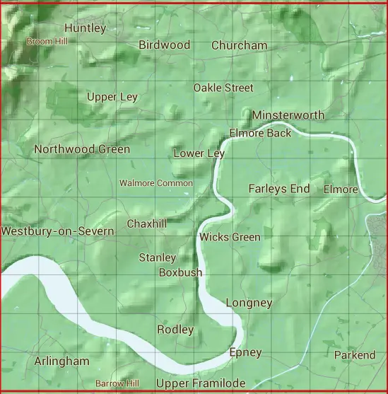
The SO71 10 square kilometre grid intersects with the settlements of Arlingham,Birdwood,Blaisdon,Broadoak,Chaxhill,Churcham,Dursley Cross,Elmore,Elton,Farleys End,Hardwicke,Highnam,Huntley,Little London,Longney,Minsterworth,Northwood Green,Parkend,Quedgeley,Rodley,Stanley,Stantway,Upper Framilode & Westbury-on-Severn.
SO71
SO71 is within the post towns of Gloucester, Gloucestershire, Mitcheldean, Gloucestershire, Stonehouse, Gloucestershire & Westbury-on-severn, Gloucestershire.
The square is within Forest of Dean District, Gloucester District, Stroud District & Tewkesbury District councils.
The SO71 national grid square measures 10 km by 10 km and has an area of 1,000 kilometres squared.
The technical term for a 10 km map square is a Hectad.
When this 10 km square is divided into a grid 10 by 10 it gives the next size of grid square. This unit is called a Monad and measures 1km square. 100 monads fit in a 10km square.
Out of the monads generated from square SO71, 523 are land and -423 are sea. Sea squares are disregarded on this site as they contain no land features.
|
|
|
|
|
|
 |
|
|
|
|
|
 |  |  |  |  |  |  |  |  |  |
 |  |  |  |  |  |  |  |  |  |
 |  |  |  |  |  |  |  |  |  |
 |  |  |  |  |  |  |  |  |  |
 |  |  |  |  |  |  |  |  |  |
 |  |  |  |  |  |  |  |  |  |
 |  |  |  |  |  |  |  |  |  |
 |  |  |  |  |  |  |  |  |  |
 |  |  |  |  |  |  |  |  |  |
 |  |  |  |  |  |  |  |  |  |
| Corner | Latitude | Longitude | Easting | Northing |
|---|---|---|---|---|
| South West Corner | 51.787852 | -2.437204 | 370000 | 210000 |
| South East Corner | 51.787852 | -2.291357 | 380000 | 210000 |
| North West Corner | 51.878211 | -2.437204 | 370000 | 220000 |
| North East Corner | 51.878211 | -2.291357 | 380000 | 220000 |