Search for Grid Square by Postcode
SJ21
Based in the Mid and West Wales region of Scotland & West Midlands English Region.
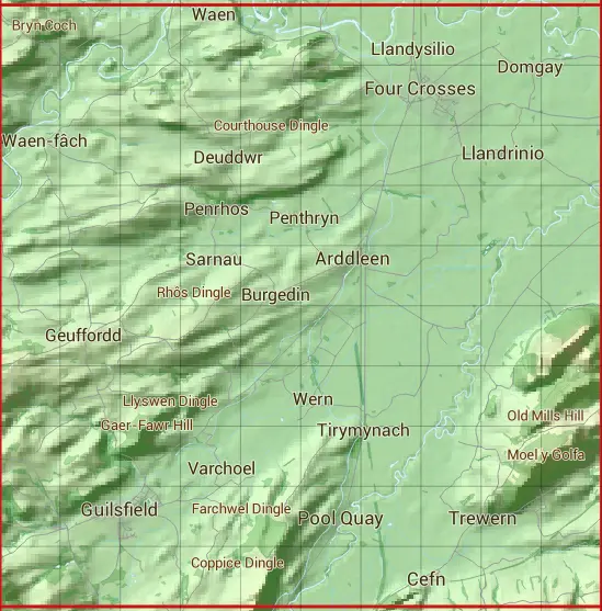
The SJ21 10 square kilometre grid intersects with the settlements of Arddleen,Cefn,Cegidfa,Criggion,Four Crosses,Geuffordd,Llandrinio,Llandysilio,Middletown,Penthryn,Pool Quay,Rhos,Trewern,Varchoel,Waen & Wern.
SJ21
SJ21 is within the post towns of Meifod, Montgomeryshire, Oswestry, Shropshire, Shrewsbury, Shropshire & Welshpool, Montgomeryshire.
The square is within Powys - Powys & Shropshire councils.
The SJ21 national grid square measures 10 km by 10 km and has an area of 1,000 kilometres squared.
The technical term for a 10 km map square is a Hectad.
When this 10 km square is divided into a grid 10 by 10 it gives the next size of grid square. This unit is called a Monad and measures 1km square. 100 monads fit in a 10km square.
Out of the monads generated from square SJ21, 521 are land and -421 are sea. Sea squares are disregarded on this site as they contain no land features.
|
|
|
|
|
|
 |
|
|
|
|
|
 |  |  |  |  |  |  |  |  |  |
 |  |  |  |  |  |  |  |  |  |
 |  |  |  |  |  |  |  |  |  |
 |  |  |  |  |  |  |  |  |  |
 |  |  |  |  |  |  |  |  |  |
 |  |  |  |  |  |  |  |  |  |
 |  |  |  |  |  |  |  |  |  |
 |  |  |  |  |  |  |  |  |  |
 |  |  |  |  |  |  |  |  |  |
 |  |  |  |  |  |  |  |  |  |
| Corner | Latitude | Longitude | Easting | Northing |
|---|---|---|---|---|
| South West Corner | 52.681780 | -3.187246 | 320000 | 310000 |
| South East Corner | 52.681780 | -3.036912 | 330000 | 310000 |
| North West Corner | 52.773048 | -3.187246 | 320000 | 320000 |
| North East Corner | 52.773048 | -3.036912 | 330000 | 320000 |