Search for Grid Square by Postcode
SJ96
Based in the North West English Region & West Midlands English Region.
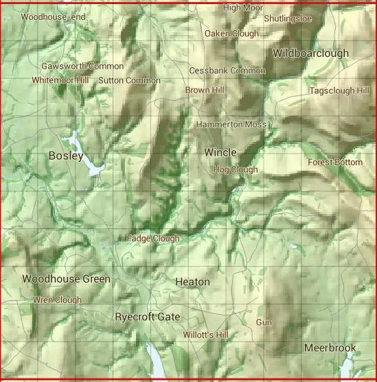
The SJ96 10 square kilometre grid intersects with the settlements of Bosley,Cloud Side,Congleton,Newtown,Oakgrove,Rushton Bank,Rushton Spencer & Ryecroft Gate.
SJ96
SJ96 is within the post towns of Buxton, Derbyshire, Congleton, Cheshire, Leek, Staffordshire, Macclesfield, Cheshire & Stoke-on-trent, Staffordshire.
The square is within Cheshire East & Staffordshire Moorlands District councils.
The SJ96 national grid square measures 10 km by 10 km and has an area of 1,000 kilometres squared.
The technical term for a 10 km map square is a Hectad.
When this 10 km square is divided into a grid 10 by 10 it gives the next size of grid square. This unit is called a Monad and measures 1km square. 100 monads fit in a 10km square.
Out of the monads generated from square SJ96, 494 are land and -394 are sea. Sea squares are disregarded on this site as they contain no land features.
|
|
|
|
|
|
 |
|
|
|
|
|
 |  |  |  |  |  |  |  |  |  |
 |  |  |  |  |  |  |  |  |  |
 |  |  |  |  |  |  |  |  |  |
 |  |  |  |  |  |  |  |  |  |
 |  |  |  |  |  |  |  |  |  |
 |  |  |  |  |  |  |  |  |  |
 |  |  |  |  |  |  |  |  |  |
 |  |  |  |  |  |  |  |  |  |
 |  |  |  |  |  |  |  |  |  |
 |  |  |  |  |  |  |  |  |  |
| Corner | Latitude | Longitude | Easting | Northing |
|---|---|---|---|---|
| South West Corner | 53.137076 | -2.151246 | 390000 | 360000 |
| South East Corner | 53.137076 | -2.001452 | 400000 | 360000 |
| North West Corner | 53.227061 | -2.151246 | 390000 | 370000 |
| North East Corner | 53.227061 | -2.001452 | 400000 | 370000 |