Search for Grid Square by Postcode
SD93
Based in the North West English Region & Yorkshire and the Humber English Region.
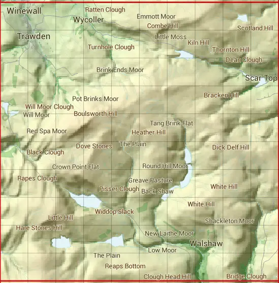
The SD93 10 square kilometre grid intersects with the settlements of Colne,Pecket Well,Trawden,Walshaw & Winewall.
SD93
SD93 is within the post towns of Burnley, Lancashire, Colne, Lancashire, Hebden Bridge, Yorkshire & Keighley, Yorkshire.
The square is within Bradford District, Burnley District, Calderdale District, Craven District & Pendle District councils.
The SD93 national grid square measures 10 km by 10 km and has an area of 1,000 kilometres squared.
The technical term for a 10 km map square is a Hectad.
When this 10 km square is divided into a grid 10 by 10 it gives the next size of grid square. This unit is called a Monad and measures 1km square. 100 monads fit in a 10km square.
Out of the monads generated from square SD93, 490 are land and -390 are sea. Sea squares are disregarded on this site as they contain no land features.
|
|
|
|
|
|
 |
|
|
|
|
|
 |  |  |  |  |  |  |  |  |  |
 |  |  |  |  |  |  |  |  |  |
 |  |  |  |  |  |  |  |  |  |
 |  |  |  |  |  |  |  |  |  |
 |  |  |  |  |  |  |  |  |  |
 |  |  |  |  |  |  |  |  |  |
 |  |  |  |  |  |  |  |  |  |
 |  |  |  |  |  |  |  |  |  |
 |  |  |  |  |  |  |  |  |  |
 |  |  |  |  |  |  |  |  |  |
| Corner | Latitude | Longitude | Easting | Northing |
|---|---|---|---|---|
| South West Corner | 53.766264 | -2.153514 | 390000 | 430000 |
| South East Corner | 53.766264 | -2.001482 | 400000 | 430000 |
| North West Corner | 53.856241 | -2.153514 | 390000 | 440000 |
| North East Corner | 53.856241 | -2.001482 | 400000 | 440000 |