Search for Grid Square by Postcode
NR61
Based in the Highlands and Islands region of Scotland.
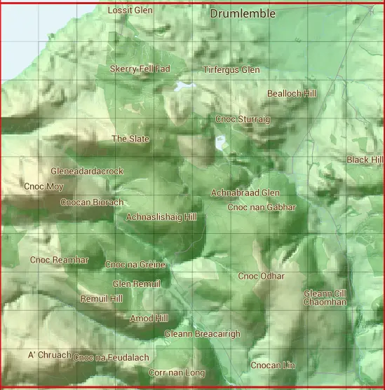
The NR61 10 square kilometre grid intersects with the settlement of Drumlemble.
NR61
NR61 is within the post town of Campbeltown, Argyllshire.
The square is within Argyll and Bute council.
The NR61 national grid square measures 10 km by 10 km and has an area of 1,000 kilometres squared.
The technical term for a 10 km map square is a Hectad.
When this 10 km square is divided into a grid 10 by 10 it gives the next size of grid square. This unit is called a Monad and measures 1km square. 100 monads fit in a 10km square.
Out of the monads generated from square NR61, 220 are land and -120 are sea. Sea squares are disregarded on this site as they contain no land features.
|
|
|
|
|
|
 |
|
|
|
|
|
 |  |  |  |  |  |  |  |  | |
 |  |  |  |  |  |  |  |  |  |
 |  |  |  |  |  |  |  |  |  |
 |  |  |  |  |  |  |  |  |  |
 |  |  |  |  |  |  |  |  |  |
 |  |  |  |  |  |  |  |  |  |
 |  |  |  |  |  |  |  |  |  |
 |  |  |  |  |  |  |  |  |  |
 |  |  |  |  |  |  |  |  |  |
 |  |  |  |  |  |  |  |  |  |
| Corner | Latitude | Longitude | Easting | Northing |
|---|---|---|---|---|
| South West Corner | 55.325325 | -5.793457 | 160000 | 610000 |
| South East Corner | 55.325325 | -5.627599 | 170000 | 610000 |
| North West Corner | 55.419776 | -5.793457 | 160000 | 620000 |
| North East Corner | 55.419776 | -5.627599 | 170000 | 620000 |
1 KM Squares within the NR61 10 KM Square
NR6010 NR6011 NR6012 NR6013 NR6014 NR6015 NR6016 NR6017 NR6018 NR6110 NR6111 NR6112 NR6113 NR6114 NR6115 NR6116 NR6117 NR6118 NR6119 NR6210 NR6211 NR6212 NR6213 NR6214 NR6215 NR6216 NR6217 NR6218 NR6219 NR6310 NR6311 NR6312 NR6313